Return to Text IconReturn to Water Chapter Text
Almanac Icon

Texas Environmental Almanac Map Section

Ecological Regions in Texas

Line

ECOLOGICAL REGIONS OF TEXAS MAP

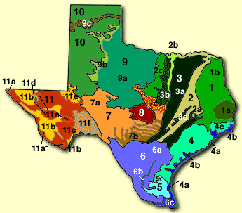
1. PINEY WOODS
1a. Longleaf Pine Forest
1b. Mixed Pine-Hardwood Forest

2. OAK WOODS & PRAIRIES
2a. Oak Woodlands
2b. Eastern Cross Timbers
2c. Western Cross Timbers

3. BLACKLAND PRAIRIES
3a. Blackland Prairie
3b. Grand Prairie

4. GULF COAST PRAIRIES
& MARSHES
4a. Dunes/Barrier
4b. Estuarine Zone
4c. Upland Prairies & Woods

5. COASTAL SAND PLAINS

6. SOUTH TEXAS
BRUSH COUNTRY
6a. Brush Country
6b. Bordas Escarpment
6c. Subtropical Zone

7. EDWARDS PLATEAU
7a. Live Oak-Mesquite Savanna
7b. Balcones Canyonlands
7c. Lampasas Cut Plain

8. LLANO UPLIFT
Mesquite Savanna, Oak &
Oak-Hickory Woodlands

9. ROLLING PLAINS
9a. Mesquite Plains
9b. Escarpment Breaks
9c. Canadian Breaks

10. HIGH PLAINS

11. TRANS PECOS
11a. Mountain Ranges
11b. Desert Grassland
11c. Desert Scrub
11d. Salt Basin
11e. Sand Hills
11f. Stockton Plateau

Source: Texas Parks and Wildlife. From LBJ School of Public Affairs, Preserving Texas' Natural Heritage. LBJ School of Public Affairs Policy Research Report #31. 1978.

Line

Return to Text IconReturn to Water Chapter Text

Next Map Texas' Eight Major Regions MapMaps Table of Contents

Almanac Table of Contents TEC Home Page

Line

Please send questions, comments, or problems with this page to ltarver@mail.utexas.edu.