Almanac Table of Contents | Chapter Four Table of Contents | TEC Home Page
NEXT PAGE* PREVIOUS PAGE Go to page 1*2*3*4*5*Notes
Source: Texas Comptroller, Fiscal Notes, May, 1993.
Though Texas has lost one-half of its coastal wetlands and 60 percent of its terrestrial wetlands in the last 200 years, there is no state law to protect wetlands. In the coastal management legislation of 1991, Texas legislators did incorporate a no-net-loss of wetlands policy for state-owned land. Though this is a positive step, the majority of wetlands are on private lands.
Three state agencies have significant roles in wetland protection: the Texas Parks and Wildlife Department, the Texas Natural Resource Conservation Commission and the Texas General Land Office. Among federal agencies, the Army Corps of Engineers and the U.S. Fish and Wildlife Service have significant responsibility for wetland protection.
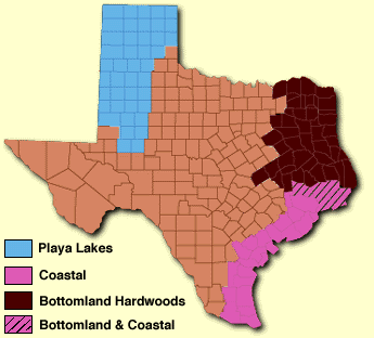
There are two major types of wetlands in Texas: inland/terrestrial wetlands and Coastal wetlands. Inland wetlands include bottomland hardwood forests in East Texas and riparian vegetation and playa lakes (shallow lakes) in West Texas. A discussion of coastal wetlands, including salt and freshwater marshes, is found in the section on water resources.
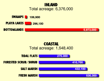
Interior wetlands account for 80 percent of the total wetland acreage in Texas. Texas has lost 60 percent of its most valuable inland wetlands: the riparian communities.(31) Most of the inland wetlands are on privately held properties.
The Texas Parks and Wildlife Department has been assigned as the lead agency to develop a state wetlands conservation plan. Though the plan will be statewide in scope, it will focus on inland wetlands, since the Texas General Land Office is developing a coastal wetlands plan. According to the Texas Parks and Wildlife Department, conserving wetlands will depend on acquisition, cooperative agreements, education and technical assistance.
| GEOGRAPHICAL DISTRIBUTION OF BOTTOMLAND HARDWOOD AND RIPARIAN VEGETATION IN TEXAS - 1980 | ||
|---|---|---|
| LOCATION | AMOUNT (EST. ACRES) | SUBTOTAL (ESTIMATED) |
| Trinity River | 305,000 | |
| Neches River | 257,000 | |
| Sabine River | 255,000 | |
| Sulphur River | 175,000 | |
| Cypress Bayou | 89,000 | |
| Angelina River | 88,000 | |
| 1,169,000 | ||
| River tributaries and riparian drainages east of the Navasota River | 3,062,000 | |
| Remaining rivers, creeks and riparian drainages | 1,742,000 | |
| Total* | 5,973,000 | |
| *Excludes swamps - 95,000 acres | ||
Source: Texas Parks and Wildlife Department, Texas Wetlands Plan: An Addendum to Outdoor Recreation Plan (Austin: TPWD, 1988).
Bottomland hardwood systems are the most diverse Texas ecosystems. Bottomland wetlands are plant communities that have been created as a result of the actions of creeks, rivers and flood plains. The bottomland hardwood forest is a part of a system that starts at a river's headwaters and ends in an estuary at the ocean. Trees found in the bottom-land hardwood forests include bald cypress, pecan, oaks, elm, cottonwood and hackberry. These hardwoods, particularly old-growth hardwoods (50 to 100 years old), contribute to the biodiversity of the wetland system. They also provide food and shelter for wildlife.
At least 189 species of trees and shrubs, 42 woody vines, 75 grasses and 802 herbaceous plants occur in Texas bottomlands. Bottomland systems also support 116 species of fish, 31 species of amphibians, 54 species of reptiles, 273 species of birds and 45 species of mammals.(32) Seventy-four species of threatened and endangered animals depend directly on bottomland hardwood systems. Over 50 percent of all the neotropical songbirds that are not listed as endangered or threatened are associated with bottomland hardwood forests. Thirty-one water species (mallards and wood ducks), eastern wild turkey, swamp rabbit, gray squirrel and 11 species of furbearers depend on bottomland hardwoods.(33)
These bottomland systems also play a vital role in maintaining water quality. By serving as a depository for sediments, wastes and pollutants from runoff, these bottomland forests enhance the water quality of bays and estuaries which lie at the lower end of these riparian corridors. Some pollutants are transformed into less harmful substances by microbiological agents in the floodplain.(34) Bottomlands also play a critical role in containing floodwaters when rivers overflow.
 Forested wetland systems support fish and wildlife populations that are an integral part of the state's $4.2 billion hunting and fishing industry.
In the 18th century, Texas had approximately 16 million acres of hardwood bottomland riparian corridors. Today, the state has 5.9 million acres of bottomland hardwoods - a 63 percent loss of bottomland hardwood. This acreage currently comprises 3 percent of the total land area of the state.(35) The majority of bottomland hardwood acres are found in East Texas; only about one million acres are scattered through the western portion of the state.
Both the Texas Forest Service and the Texas Parks and Wildlife Department recognize that there has been a steady decline in bottomland hardwood forests since the early 19th century.(36) Texas Parks and Wildlife shows that losses of bottomland hardwoods are continuing in Texas at the rate of about 12 percent per decade.(37) Reservoirs, development and agriculture threaten bottomland hardwood. But hardwood pulp (ground-up wood fiber) consumption is responsible for the recent upward trend in exploitation of bottomland ecosystems in Texas. Pulpwood consumption in the U.S. is expected to more than double from 82 million tons in l986 to 173 million tons by 2040, and pulpwood demand worldwide has further stimulated increased consumption of hardwoods. This demand is fueled by the demand for high quality computer paper, white cardboard shipping cartons and other paper products, such as six-pack soda carriers, which require a higher hardwood fiber component.(38) In the U.S., Texas ranks seventh in pulpwood consumption by manufacturing industries.(39)
Mitsubishi has a low-grade hardwood mill in Beaumont that makes chips from hardwood and sends them to Japan to be converted to high grade writing and publishing paper for domestic use. Since Mitsubishi set up its company in 1992, the price of a cord of hardwood in East Texas has risen from $4.00 to $11.00. Source: Texas Forest Service.
| PROJECTED STATEWIDE BOTTOMLAND HARDWOOD LOSS THROUGH DIRECT IMPACTS FROM 44 RESERVOIRS LISTED IN THE TEXAS WATER PLAN (TDWR 1984).
Acreage Remaining (1980) = 5,973,000. | |
|---|---|
| TIME PERIOD | PROJECTED LOSS (ACRES) |
| 1985-1989 | - 21,000 |
| 1990-1999 | - 41,000 |
| 2000-2030 | - 200,000 |
| Projected total hardwood loss | -262,000* (4%) |
| Note: The Texas Water Development Board's 1990 State Water Plan projects that only 14 reservoirs are needed in the next 50 years. However, a larger number of reservoirs might be considered. | |
| *This represents 4 percent of the estimated remaining bottomland hardwood and riparian vegetation (5,973,000 acres). | |
| Source: Texas Parks and Wildlife Department, Texas Wetlands Plan: An Addendum to Outdoor Recreation Plan. 1988. | |
Texas playa lakes - shallow, circular basins - are the wintering wetland habitat for millions of waterfowl that migrate from as far north as Canada. There are 20,000 playa lakes located in 37 counties of the Texas Panhandle and South Plains. The total area of playa basins has been estimated at 296,000 acres. Fifteen million birds annually migrate through these playas in the fall and spring on their way to and from wintering habitat on the Gulf Coast and farther south.(40) Ducks, geese and sandhill cranes also use these playas as winter havens. The majority of these oases of wildlife habitat are located within intensively cultivated, privately held farmland. Precipitation and irrigation runoff contribute to the development of these wetlands. Land use practices and changes in irrigation methods intended to limit runoff are reducing the capacity of playas to provide food and water for waterfowl.
NEXT PAGE* PREVIOUS PAGE Go to page 1*2*3*4*5*Notes
Please send questions, comments, or problems with this page to ltarver@mail.utexas.edu.