Almanac Table of Contents | Chapter Four Table of Contents | TEC Home Page
NEXT PAGE* PREVIOUS PAGE Go to page 1*2*3*4*5*Notes
The Texas Parks and Wildlife Department is responsible for investigating any pollution that may affect fish and wildlife in Texas.
The Texas Parks and Wildlife Department's regional offices for pollution response received a total of 402 fish kill and pollution complaint calls in 1992.
| YEAR | CALLS |
|---|---|
| 1988 | 226 (132 of these were fish and wildlife kill reports) |
| 1989 | 290 (183 fish and wildlife kill reports) |
| 1990 | 275 (137 fish and wildlife kill reports) |
| 1991 | 396 (142 fish and wildlife kill reports) |
| 1992 | 402 (147 fish and wildlife kill reports) |
| 1993 | 330 (132 fish and wildlife kill reports) |
According to the Texas Parks and Wildlife Department, the majority of calls reporting pollution and fish kills originate in areas of high urban and industrial development. This is due both to the increased pressure on the environment in these areas as well as the larger number of people who observe and report problems. The upper Texas coastal area (Houston-Port Arthur/Beaumont) normally has the highest number of incidents for each year. Other regions that have a significant number of reports are the regions that include Dallas-Fort Worth metroplex, the Corpus Christi area and the Lower Rio Grande Valley.(24)
| LOSS OF FISH AND WILDLIFE HABITAT |
|---|
| Springs and Spring Runs |
| Habitat: Due to their unique characteristics (constant temperature, clear water and in some cases isolation from connecting watercourses), these habitats are natural settings for many rare and unusual species. Status: A significant number of Texas springs have gone dry from man's activities. Over pumping of groundwater for irrigation and human use has led to lowering of groundwater tables and decreased or ceased spring discharge (the Edward's Aquifer is one example). Texas historically had 281 major springs. By 1973 only 2 of 4 very large and 17 of 31 large springs were still flowing. Future: Increasing pressures on groundwater and aquifers will continue to impact existing springs, affecting associated flora and fauna. |
| Bottomland Hardwoods |
| Habitat: Texas' most diverse terrestrial habitat. An estimated 16 million acres of riparian (river/stream associated) habitat existed in early Texas. Status: More than 60 percent has been lost to agricultural conversion, timber production, urban/industrial development and reservoir construction. Future: Additional water development, new technologies in the use of hardwood pulp, and forestry practices threaten this habitat, especially in East Texas. |
| Coastal Wetlands |
| Habitat: The most important estuarine habitat since 90 percent of commercially and recreationally important species depend on these wetlands. One-third of all endangered species occur here and millions of waterfowl overwinter in this habitat. Status: Some 53 percent of all USA wetlands have been lost to dredge and fill for development, subsidence and agricultural conversion. Texas has lost more than 50 percent of its original 1.2 million acres. Thirty-five percent of losses have occurred since 1950. Almost half of Texas estuarine areas are closed, or conditionally closed, to shellfish harvest because of pollution. Future: Coastal development, loss of freshwater inflows and sea level rise threaten remaining wetlands. |
| South Texas Brushlands |
| Habitat: A unique habitat where more than 500 vertebrate species and more than 260 species of woody plants occur. Numerous endangered species including the ocelot and jaguarundi are found here. Status: Since the 1920s, more than 95 percent of the original brushlands have been converted to agricultural and urban use. Future: Restoration of brush and acquisition of remaining habitat is key to maintaining this unique ecosystem. |
| Texas Prairie |
| Habitat: More than 20 million acres of tallgrass communities once covered the Texas Blacklands Prairie, the Fort Worth Prairie, the Feyette Prairie and the Coastal Prairie. Status: Of the 12.6 million acres of the Blacklands Prairie, fewer than 100,000 acres (less than 10 percent) of native sod exist today. A million acres of Coastal Prairie have been urbanized by Houston. Endangered species such as the Attwater's prairie chicken are on the edge of extinction because of such losses. Future: Continued losses to this habitat is expected. Restoration, cooperative actions and private landowners will be key to saving these prairie habitats. |
Source: Texas Parks and Wildlife Department, Natural Agenda: A Strategic Plan for Texas Parks and Wildlife, February 1, 1993.
Today the overwhelming majority of losses of and threats to wildlife, plants and natural communities are a direct result of habitat alteration or destruction, caused by urbanization, timber production, reservoirs and agriculture.(25) According to the Texas Parks and Wildlife Department, the following are examples of habitat loss in Texas:
Another indication of ecological change is the documentation that marine and brackish fishes have invaded the lower Rio Grande basin as a result of high salinity, which in turn is forcing out freshwater fish.(27)
Texas has 133 million acres of wildlife habitat remaining. This includes springs, bottomland hardwoods, coastal wetlands, south Texas brush lands, and Texas prairies. Ninety-seven percent of the land in Texas is privately held. Therefore, the continued existence of wildlife habitat is very much in the hands of the private sector.
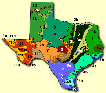
Wildlife habitat in Texas is broken into eight categories:(28)
| ECO-LOCATION MAP NOW AVAILABLE |
|---|
|
To encourage people to make environmentally-sound choices about where to live and do business in the Austin area, the Hill Country Foundation has developed a color map which includes text and graphics illustrating geologic and natural history of Travis County and parts of Williamson and Hays Counties. The map includes information on endangered species habitat areas, watersheds, aquifer recharge zones, 100-year flood plains, school district boundaries and location of major employers. The Hill Country Foundation has produced a creative tool to help citizens and businesses manage urban growth in environmentally sensitive areas. The map is being made available to the real estate and business communities to be used as a corporate relocation tool. Maybe other communities will join in this approach. Contact: Hill Country Foundation, 1800 Guadalupe, Austin, Texas 78701. |
Texas Parks and Wildlife Department owns and/or leases approximately 700,000 acres for wildlife management areas.
The funds used for acquisition and operation of state wildlife management areas is derived from an excise tax on hunting equipment and from hunting stamps. No general revenue is used.
In Texas, the United States Fish and Wildlife Service manages 18 national wildlife refuges, totaling 417,000 acres.
Wetlands ecosystems are second only to the rain forests in the number of wildlife and plant species that depend on them for feeding and habitat.
Wetlands are defined "as areas that are inundated or saturated by surface or ground water at a frequency and duration sufficient to support, and that under normal circumstances do support, a prevalence of vegetation typically adapted for life in saturated soil conditions."(29) Wetlands include marshes, swamps, bogs, and shallow lakes and can include floodplains and mudflats.
Among their many valuable functions, which include filtering pollutants and preventing erosion and flooding, wetlands are the breeding, feeding and nesting grounds for many endangered species and plants and for non-endangered wildlife and natural communities.
In recognizing the tremendous importance of wetlands, the federal government established a national goal of "no overall net loss of wetlands." The Clean Water Act of 1972 is the law that has had the greatest impact upon wetlands. Section 404 of the Clean Water Act requires a permit from the Army Corps of Engineers for any dredging or filling into waters of the United States. This includes both terrestrial and coastal wetlands.
In Texas in 1993, of the 1,510 Section 404 permits issued for dredging and filling wetlands, 733 were found in coastal areas. Only 20 to 30 inland permits are issued a year and those are usually for reservoirs that significantly affect wetlands.(30) This does not indicate that inland wetlands are less threatened by human activities, however. The 404 permit process is discussed in the Water Quality chapter.
NEXT PAGE* PREVIOUS PAGE Go to page 1*2*3*4*5*Notes
Please send questions, comments, or problems with this page to ltarver@mail.utexas.edu.