Almanac Table of Contents | Chapter Two Table of Contents | TEC Home Page
NEXT PAGE * PREVIOUS PAGE * NEXT CHAPTER
Go to page 1*2*3*4*5*6*7*8*9*Notes
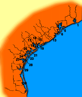
Thirty-two of Texas' 80 segments of estuarine waters are classified as shellfish waters. (A "segment" is a unit designated by the state for purposes of monitoring bodies of water. For estuaries, a segment is usually a seven-mile stretch of coastline.) About one million sport fishermen and 20,000 commercial fishermen catch more than 100 million pounds of coastal fish and shellfish each year in Texas' coastal waters, contributing an estimated $2.9 billion to the state's economy.(111) These habitats also attract hunters, photographers, swimmers, campers, bird-watchers, boaters and sightseers, generating an additional $3 billion dollars per year.(112)
As more people move into the coastal area, fragile habitat is being lost. More than one-third of the state's population now lives and works within 100 miles of the coast. Twenty percent of the state's population lives in the four-county area surrounding Galveston Bay - Galveston, Chambers, Brazoria, and Harris counties. The Texas General Land Office estimates that by the year 2000 more than 5.3 million people will live in the coastal areas.(113) Along with population growth will come increased development and demands for water and wastewater facilities, and potential threats of pollution to estuaries, wetlands and bays.
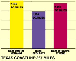
Source: Texas General Land Office, EnviroNomics, Winter 1993.
In 1991, the Texas Legislature directed the General Land Office to head up a new Coastal Coordination Council, which has since developed a Coastal Zone Management Plan with other state agencies. The Plan may become effective in 1995. The Management Plan sets policies, standards and regulations affecting private and public property in all counties contiguous to the Texas coastline. It can impact such activities as development permits, fill-and-dredge operations, siting of oil and gas waste-disposal pits, agricultural activities and highway construction.
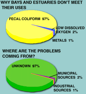
Most of these water quality problems are related to high levels of fecal coliform bacteria in Texas' shellfish harvesting areas. In 1993, the Texas Department of Health closed or restricted 625.3 miles of Texas coast to oyster harvesting due to high fecal coliform levels.(116) In addition, parts of Lavaca Bay are closed to finfish and blue crab harvesting because of mercury contamination.(117)
| USE SUPPORT SUMMARY FOR CLASSIFIED BAYS | ||||
|---|---|---|---|---|
| USE | TOTAL MILES | MEET USE | PARTLY MEET USE | DON'T MEET USE |
| All Uses | 1,990.7 | 1,157.9 | 161.2 | 671.6 |
| Aquatic Life Support | 1,990.7 | 1,956.9 | 33.1 | 0.7 |
| Contact Recreation | 1,987.0 | 1974.7 | 4.1 | 8.2 |
| Noncontact Recreation | 3.7 | 2.8 | 0.9 | 0.0 |
| Fish Consumption | 1,990.7 | 1,911.0 | 0.0 | 79.7 |
| Shellfishing* | 1,990.7 | 1,168.9 | 166.6 | 635.5 |
*About 70 miles of Texas bays no longer can support shellfishing, and have therefore been designated as "non attainable" waters.
Source: Texas Natural Resource Conservation Commission, State of Texas Water Quality Inventory, 12th Edition (Austin: TNRCC, 1995), 148.
Source: Texas Natural Resource Conservation Commission, State of Texas Water Quality Inventory, 12th Edition (Austin: TNRCC, 1995), 149.
| RISKS TO ESTUARIES |
|---|
|
As part of the program, a five-year assessment study of Galveston Bay preceeded the development of a management plan that addressed water quality, habitat, wildlife and human health aspects of the estuary. A draft plan, known as the Galveston Bay Plan, was released by the Galveston Bay National Estuary Program in 1994. In 1995, the Environmental Protection Agency approved the Galveston Bay National Estuary Program.
The estimated cost to the state for implementing the recommendations in the Galveston Bay Plan is $1.5 million per year in 1996 and 1997. Among the initiatives outlined in the Galveston Bay Plan are projects to:
Wetlands furnish essential habitat for many species of waterfowl, mammals, fish and other wildlife. Wetlands can be located either near the coast (coastal wetlands) or further inland (interior wetlands). Texas' 2,575 million square acres of coastal wetlands act as a natural filter for various natural and man-made contaminants, protecting the overall estuarine system.
Wetlands are defined in state law as areas that are inundated or saturated by surface or groundwater at a frequency and duration sufficient to support, and that under normal circumstances do support a prevalence of vegetation typically adapted for life in saturated soil conditions. Coastal wetlands include salt and fresh marshes, tidal inlands and forested scrub.
Coastal wetlands are imperative for maintaining coastal water quality in Texas because they help filter out pollutants and because they help control excessive runoff to the bays. They also provide important nutrients for the bay ecosystem. In 1991, wetlands were recognized for the first time as "waters of the state" under Texas Water Quality Standards and are now afforded better water quality protection. Also, in 1991, the State Legislature adopted a no net loss of state-owned wetlands policy for the state of Texas. This policy has led the state Parks and Wildlife Department to develop a wetlands management plan, which other state agencies are directed to uphold to protect wetlands from destruction (see Wildlife chapter for details).
Like estuaries, wetlands are subject to a variety of threats. In 1956, the U.S. Fish and Wildlife Service estimated that Texas had 937,400 acres of coastal wetlands. In 1980, the Texas Parks and Wildlife Department estimated there were 611,760 acres, a 35 percent decrease in less than 25 years. And saltwater intrusion caused by canals, land subsidence (sinking) and drainage ditches has severely damaged some remaining wetlands.(122) Unfortunately, it is difficult to measure precisely the number of acres of wetlands in Texas, in part because the last large-scale inventory of coastal wetlands in Texas was in 1979. In addition, wetlands are difficult to survey because their appearance changes drastically with drought or flood conditions.
Subsidence of land along the coast and the loss of coastline caused by soil erosion and a rising sea level have contributed to the loss of coastal wetlands. Each year, 225 acres of Gulf shoreline wash into the sea. An estimated 21,000 acres of shoreline were lost between the mid 1800s and 1982.(123) In some areas of Texas, overpumping of groundwater has led to the subsidence, or sinking, of the land. This impact alone has led to the loss of about 24,600 acres of marshes existing since the 1950s in the four-county Galveston Bay area.(124)
Another significant cause of coastal wetlands loss is conversion of wetlands for development. Wetlands are sometimes drained and turned into rangeland or cropland or fitted for urban use. They are sometimes impacted by dredging and filling operations, conducted mainly to widen canals for navigation purposes, because dredged soil is often deposited in the wetlands' open water sites.
One dramatic example of wetlands destruction resulting from land-use changes has been the loss of shoal grass in the Lower Laguna Madre. Over the past 20 years, there has been a 60 percent reduction in shoal grass beds in this wetland. Studies attribute the loss of sea grasses to suspension of fine particle sediment caused in part by the dredging of the Gulf Intracoastal Waterway.(125)
With the Clean Water Act of 1977 the federal government initiated the first truly comprehensive wetland protection program. Section 404 of the Clean Water Act requires the Army Corps of Engineers to issue a permit for any dredging or filling of waters of the United States. In 1986, this provision was expanded to include wetlands and water serving as habitat for migratory birds or endangered species. Normal farming, forestry and ranching activities are exempt from permit requirements.
Though the U.S. Army Corps of Engineers actually issues the Section 404 Permits, applicants must also obtain certification from the state that a permit will not violate state water quality standards under Section 401 of the Clean Water Act. Of the 1,519 permits issued in 1993 by the U.S. Army Corps of Engineers, 733, or almost half, were found in the 18 counties along the Texas coast.(126)
| ESTIMATED LOSS OF WETLAND BY SOURCE IN GALVESTON BAY | ||
|---|---|---|
| CAUSE | TYPE OF WETLAND AFFECTED | NET LOSS, 1950-90 (ACRES) |
|
Subsidence and sea level rises (aquifer overpumping) | Estuarine bay marshes | 24,600 |
| Conversion to urban and agricultural use | Freshwater marshes | 35,600 |
| Dredge and fill activities | Estuarine bay marshes | 7,070 |
|
Modifications of shoreline (flood control, salt water barriers, cooling ponds) | Estuarine bay marshes | 6,300 |
Source: Galveston Bay National Estuary Program, Galveston Bay Environmental Characterization Report (Houston: Galveston Bay National Estuary Program, 1993), 218.
More than 102,000 vessels cart some 250 million tons of cargo to Texas' largest ports each year, about 45 percent of which is petroleum and oil-related.(127) Spills and dumping from these ships during transit are among the chief causes of both marine and beach debris. Off-shore oil rigs and other petroleum-industry activity result in the discharging of chemicals and oil into Texas coastal waters, further degrading their quality.
About a quarter of the nation's refining capacity and almost 65 percent of its petrochemical capacity are located along 367 miles of Texas shoreline. This concentration of industry means that the Gulf of Mexico serves as a major shipping route for the transport of petroleum products. In 1989, more than 115,000 tanker and barge transports carried some 1.6 billion barrels of crude oil, fuels and other petroleum products across Texas Gulf waters.(128)
The concentration of petrochemical industry also means that the Gulf is a likely site for oil spills. In the summer of 1990, the Norwegian tanker Mega Borg exploded, discharging 4.6 million gallons of crude oil into the Gulf. A collision between a tanker and tank-barge in August, 1990, caused some 700,000 gallons of oil to spill into Galveston Bay, blocking the Houston Ship Channel for days.(129)
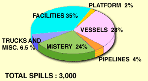
In response to these spills, the Texas Legislature in 1991 passed the Oil Spill Prevention and Response Act. The Act put the General Land Office in charge of oil spills and established a clean-up fund, generated by a two-cent-per-barrel fee on all crude oil being loaded or unloaded in Texas ports, to clean up "mystery spills" for which no responsible party can be identified.
Between 1991 and 1993, there were more than 3,000 individual oil spills in coastal waters, about 25 percent of which were classified as mystery spills. These and other spills caused the fund to be used 45 times in 1992 and 1993, for a total expenditure of approximately $150,000. Of this amount, $70,000 was later recovered by locating responsible parties.(130)
The state of Texas holds title to 4 million acres of submerged land off the coast, which can be leased for oil and gas activity. In 1993, 11 rigs were operating in state waters offshore, two were operating in inshore waters, and another 227 on state land.(131) Oil and gas production on federal waters is managed by the U.S. Department of the Interior. The central and western Gulf off the coasts of Texas and Louisiana have one of the highest oil and gas activities in the world.
Source: Texas General Land Office, EnviroNomics (Winter 1993), 3.
Improperly disposed of waste in Gulf waters is a major threat to marine mammals, birds and other aquatic life. Waste materials thrown off of garbage ships often entangle, maim and kill these aquatic creatures. Fish and marine mammals often eat synthetic materials, which then enters the food chain. Finally, this debris accumulates on the Texas coast, affecting both tourism and estuarine habitats. See the Public Lands chapter for a further discussion of beach debris.
To address this beach debris problem, the Gulf of Mexico has been earmarked as a special area under the international MARPOL treaty, which regulates marine pollution around the world. Under the treaty, the dumping of solid waste by any boat from any nation would be prohibited in a special area. The designation of "special areas," however, will not take effect until all countries sharing the Gulf have constructed special port garbage reception facilities.
| HOW ARE 404 PERMITS APPROVED? |
|---|
|
NEXT PAGE * PREVIOUS PAGE * NEXT CHAPTER
Go to page 1*2*3*4*5*6*7*8*9*Notes
Please send questions, comments, or problems with this page to ltarver@mail.utexas.edu..