
Almanac Table of Contents | Chapter One Table of Contents | TEC Home Page
NEXT PAGE * PREVIOUS PAGE Go to page 1*2*3*4*5*6*7*8*Notes
Texas Environmental Almanac, Chapter 1, Water Quantity, Page 6
Assuring a safe, adequate supply of water for irrigation, for industrial and municipal needs and for the environmental needs of individual rivers, bays and estuaries is largely a regional question. Most projections show that Texas has enough water in the state as a whole, but each region in the state has different water resources, has differing needs and faces different problems. This section looks at eight major regions in Texas, and highlights the expected demands, supplies and problems in each of them.
 The longest river in Texas? The Rio Grande, which begins in Colorado and covers 1,896 miles, second only to the Missouri-Mississippi.
The second longest? The Red River, which forms the border between Texas and Oklahoma.
The shortest river? The Comal, only two-and-a-half miles long.
What's the biggest aquifer? The Ogallala Aquifer, which covers four states, and in 1974 had more than 281.7 million acre-feet of recoverable groundwater. By 2031, this total will have been reduced to 76.1 million acre-feet in Texas.
Source: Texas Water Development Board, Texas Water Facts, 4.
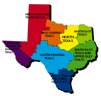 TEXAS EIGHT MAJOR REGIONS MAP
Upper Rio Grande and Far West Texas
Water Resource Problems:
- Very limited water supply. The major aquifers in the area - the Hueco Basin and the Mesilla Basin - are shared by New Mexico, Texas and Mexico, and provide nearly all municipal and industrial needs. Groundwater from the Hueco and Mesilla are being "mined" and saline water from adjacent saline bearing sands is encroaching upon higher quality groundwater.
- High salinity in the Rio Grande river due to frequent low flows and municipal and agricultural return flows.
- Hundreds of small, unincorporated communities along the border lack adequate water supply and wastewater.
| UPPER RIO GRANDE AND FAR WEST TEXAS WATER SUPPLY AND DEMAND DISTRIBUTION, 1990 - 2040 |
|---|
| Major Cities: | El Paso | Average Annual Precipitation: | 8 to 18 inches |
| Population, 1990: | 615,196 | Annual Net Evaporation Rate: | 66 inches
|
| Total Water Use, 1990: | 526,103 acre-feet | Major Economic Sectors: | Mineral Production,Manufacturing, Retail and Wholesale Trades, Agriculture, Tourism and International Trade.
|
| Population, 2040: | 1,367,668 | Physiography: | Flat to rolling to mountainous, sparsely-vegetated desert with flat, floodplain areas adjacent to Rio Grande.
|
| Total Water Use, 2040: | 559,245 acre-feet | Primary River: | Rio Grande |
| | Major Aquifer: | Hueco-Mesilla Bolson |
|---|
High Plains and Trans-Pecos
Water Resource Problems:
- Very scarce surface water supplies, mainly available for municipal needs. New supplies will be needed for some cities in the area to meet projected demand. Conveyance (mixture of groundwater and surface water) and further development of new reservoirs are the likely options.
- Ogallala Aquifer is being dried up, supplying 5.5 million acre-feet of irrigation to 4.6 million acres in the South Plains area, south of the Canadian River, and 1.3 million acres in the Northern High Plains. At present consumption levels, Ogallala Aquifer will only be able to support 5.2 million acres by 2000 with conservation efforts. Of particular concern is the the South Plains area, south of the Canadian River. At present rates of consumption, only 23 percent of the present acreage in the South Plains could be supplied by the Ogallala by the year 2030.(59)
- Groundwater in many areas has high fluoride, arsenic and nitrate levels.
HIGH PLAINS AND TRANS-PECOS
WATER SUPPLY AND DEMAND DISTRIBUTION, 1990 - 2040
|
|---|
|
Major Cities: | Lubbock, Amarillo, Midland, Odessa | Average Annual Precipitation: | 10 to 22 inches
|
|---|
|
Population, 1990: | 1, 097, 609 | Annual Net Evaporation Rate: | 53 inches
|
|---|
|
Total Water Use, 1990: | 6, 113, 219 acre-feet | Major Economic Sectors: | Agriculture, Agri-business, Mineral Production, Manufacturing, Retail and Wholesale Trade.
|
|---|
|
Population, 2040: | 1,583,323 | Physiography: | In the High Plains, level plains in the south and southeast changing to arid, flat plains of Trans-Pecos area rising to high mountains.
|
|---|
|
Total Water Use, 2040: | 5,320,539 acre-feet | Primary Rivers: | Canadian, Red, Brazos, Colorado, Pecos
|
|---|
| Major Aquifers: | Ogallala, Cenozoic, Pecos,Alluvium, Edwards-Trinity
|
|---|
West Central Texas
Water Resource Problems:
- Very scarce surface and groundwater supplies.
- High nitrate concentrations in Seymour Aquifer, caused partly by natural phenomena and partly by pollution from septic tanks, cesspools, feedlots and agriculture, preclude its use for drinking water. Water also has high fluoride content.
- Water shortages during droughts in smaller cities. Larger cities may need new supplies. Natural saline water in Red and Brazos River Basins precludes full use of these waters.
- Agricultural production has increased infiltration of water from rainfall and irrigation, leading to water-logged, unproductive soils.
WEST CENTRAL TEXAS
WATER SUPPLY AND DEMAND DISTRIBUTION, 1990 - 2040
|
|---|
|
Major Cities: | Abilene, Wichita Falls | Average Annual Precipitation: | 19 to 30 inches
|
|---|
|
Population, 1990: | 518,465 | Annual Net Evaporation Rate: | 51 inches
|
|---|
|
Total Water Use, 1990: | 370, 955 acre-feet | Major Economic Sectors: | Mineral Production, Agriculture, Agri-Business, Manufacturing, Retail and Wholesale Trade, Government.
|
|---|
|
Population, 2040: | 603,856 | Physiography: | Rolling prairies in the west turn to flat, relatively treeless prarie and cross timber country in the east.
|
|---|
|
Total Water Use, 2040: | 344,896 | Primary Rivers: | Red, Colorado, Brazos
|
|---|
|
| Major Aquifer: | Seymour
|
|---|
North Texas
Water Resource Problems:
- The Upper Trinity River Basin is nearing its potential to provide water for the area. Water is being imported from river basins to the east to meet major municipal needs. Future water projects will come from these eastern river basins.
- Groundwater levels in the Trinity Aquifer have been lowered severely, affecting the cost and quality of water used for agriculture and for the city of Stephenville in the northern part of the region.
NORTH TEXAS
WATER SUPPLY AND DEMAND DISTRIBUTION, 1990 - 2040
|
|---|
|
Major Cities: | Dallas, Fort Worth, Denton, Sherman, Waco, Temple | Average Annual Precipitation: | 26 to 40 inches
|
|---|
|
Population, 1990: | 4,852,254 | Annual Net Evaporation Rate: | 41 inches
|
|---|
|
Total Water Use, 1990: | 1,258,691 acre-feet | Major Economic Sectors: | Manufacturing, Retail and Wholesale Trade, Finance, Services, Transportation and Tourism.
|
|---|
|
Population, 2040: | 9,136,942 | Physiography: | From flat to rolling wooded cross timbers in the west to wooded rolling hills and flat lands of the Blacklandsand Post Oak Belt in the east.
|
|---|
|
Total Water Use, 2040: | 1,934,135 acre-feet | Primary Rivers: | Red, Trinity, Brazos
|
|---|
|
| Major Aquifer: | Trinity
|
|---|
Northeast Texas
Water Resource Problems:
- Some groundwater has high concentrations of iron and high acidity, necessitating deeper wells or expensive treatment.
- Proposed water supply projects such as the Big Sandy project on the Sabine River and the proposed Water Bluff and Little Cypress Reservoir could damage the environmental needs of downstream habitat.
NORTHEAST TEXAS
WATER SUPPLY AND DEMAND DISTRIBUTION, 1990 -2040
|
|---|
|
Major Cities: | Texarkana, Tyler, Longview, Marshall | Average Annual Precipitation: | 42 to 48 inches
|
|---|
|
Population, 1990: | 901, 300 | Annual Net Evaporation Rate: | 20 inches
|
|---|
|
Total Water Use, 1990: | 595, 849 acre-feet | Major Economic Sectors: | Manufacturing, Wholesale and Retail Trade, Services, Mineral Production, Agriculture and Agri-business.
|
|---|
|
Population, 2040: | 1,127,011 | Physiography: | Flat wooded areas to very wooded rolling hills and river valleys.
|
|---|
|
Total Water Use, 2040: | 785,981 acre-feet | Primary Rivers: | Red, Sulphur, Cypress, Sabine, Neches |
|---|
|
| Major Aquifer: | Carrizo-Wilcox
|
|---|
South Central Texas
Water Resource Problems:
- The Edwards Aquifer - the sole source of water for San Antonio's one million people - is also essential to provide stream inflow to the Leona, San Pedro, San Antonio, Hueco, Comal and San Marcos Springs north of San Antonio, as well as to Barton Springs in the Austin area. Continued use of the Edwards Aquifer is threatening these streams' ecosystems, curtailing the recreational opportunities they have long afforded. The Sierra Club, a national environmental group, is currently suing the city of San Antonio in federal district court to limit pumpage to protect Comal and San Marcos Springs, which are home to several endangered species. The judge ordered the city to prepare an emergency withdrawal reduction plan in 1994 to limit pumpage from the Edwards Aquifer in order to assure protection of the Texas Blind Salamander and the San Marcos Salamander, among other species.
- Overpumping of Edwards Aquifer will eventually lead to encroachment of saline water in some areas. Naturally occurring hydrogen sulfide continues to be a costly problem because it must be removed before water can be used for drinking.
- Pumping from the Carrizo Aquifer in the Winter Gardens area has lowered water levels 400 feet, causing encroachment of poor quality water into the aquifer.
- The Texas Hill Country west of Austin and north of San Antonio suffer from groundwater supply problems because of declining water levels and poor water quality. For example, the communities of Fredericksburg, Johnson City, Kerrville and other cities in the area have begun using surface water to supplement their groundwater use. Groundwater tends to be high in salts and other minerals.
- If current water usage patterns continue, the city of Austin, which relies on surface water supplies, will face water shortages within 50 years.
SOUTH CENTRAL TEXAS
WATER SUPPLY AND DEMAND DISTRIBUTION, 1990 - 2040
|
|---|
|
Major Cities: | San Antonio, Austin, San Angelo, Del Rio | Average Annual Precipitation: | 14 to 42 inches
|
|---|
|
Population, 1990: | 2, 718, 316 | Annual Net Evaporation Rate: | 17 inches
|
|---|
|
Total Water Use, 1990: | 1, 564, 590 acre-feet | Major Economic Sectors: | Manufacturing, Retail and Wholesale Trade, Agriculture, Agri-business, Mineral Production, Government and Tourism.
|
|---|
|
Population, 2040: | 6,453,944 | Physiography: | Rolling, grassy prairies in the west leading to hilly, wooded hill country in the central and eastern parts of the region.
|
|---|
|
Total Water Use, 2040: | 1,995,852 acre-feet | Primary Rivers: | Colorado, Guadalupe, Nueces, San Antonio, Rio Grande
|
|---|
|
| Major Aquifers: | Edwards-BFZ, Edwards-Trinity, Carrizo-Wilcox
|
|---|
Southeast Texas and Upper Gulf Coast
Water Resource Problems:
- The pumping of the Gulf Coast Aquifer has caused subsidence, and has allowed salt water encroachment from the bays. The Harris-Galveston Coastal Subsidence District regulates the amount of groundwater removed from the Gulf Coast Aquifer in the Houston/Galveston area and is developing a conversion plan to convert areas from groundwater to surface water by 2010. The Brazos River Authority is developing the Allen's Creek Reservoir to meet new demand for surface water.
- Bays and estuaries require significant amounts of inflow to protect habitats and economic survival, but inflows will decline as population grows. New reservoirs proposed for the coastal area to increase the supplies along the major river basins will impact estuary and bay habitat.
- Salt water intrusion during periods of low flow due to drought conditions or upstream consumption in Trinity and Neches Rivers can contaminate fresh water supply.
SOUTHEAST TEXAS AND UPPER GULF COAST
WATER SUPPLY AND DEMAND DISTRIBUTION, 1990 - 2040
|
|---|
|
Major Cities: | Houston, Galveston, Beaumont, Orange, Port Arthur, Victoria | Average Annual Precipitation: | 32 to 56 inches
|
|---|
|
Population, 1990: | 4,933,364 | Annual Net Evaporation Rate: | 45 inches
|
|---|
|
Total Water Use, 1990: | 3,698,499 acre-feet | Major Economic Sectors: | Manufacturing, Mineral Production, Finance, Services, Retail and Wholesale Trade, Agriculture, Tourism, Commercial Shipping and Fishing and Government.
|
|---|
|
Population, 2040: | 9,437,876 | Physiography: | Rolling, hilly wooded area in East Texas turning into grassy, flat coastal plains.
|
|---|
|
Total Water Use, 2040: | 4,195,071 acre-feet | Primary Rivers: | Sabine, Neches, Trinity, San Jacinto, Brazos, Colorado, Lavaca, Guadalupe
|
|---|
|
| Major Aquifer: | Gulf Coast
|
|---|
South Texas and Lower Gulf Coast
Water Resource Problems:
- Surface water rights are totally appropriated and in drought periods - if water use rights are exercised - requirements cannot be met.
- Groundwater is naturally high in salinity and most cannot be used for drinking water purposes in the Lower Rio Grande Valley. However, some less-saline water may be converted to drinking water through desalting processes.
- Bays and estuaries and other environmental needs must compete with the growing population of the region.
- The Texas Water Development Board projects that the city of Corpus Christi will be unable to meet its water needs from Lake Corpus Christi and Choke Canyon Reservoir by 2010. Although the two reservoirs could provide the city an estimated 220,000 acre-feet per year, environmental releases required by the state to protect the needs of downstream habitat will reduce available supplies by 30,000 acre-feet per year. Further, recreational users want to maintain high water levels for boating purposes.(60)
- Brownsville and Harlingen in Cameron County will exceed their permitted rights to surface water by 2010 and will need to purchase additional water rights, probably as agricultural land is converted to suburban use.
- Many unincorporated subdivisions lacking proper water and wastewater facilities exist within the region, predominantly within Hidalgo and Cameron counties. In Hidalgo County alone, there are an estimated 130,000 residents living without proper wastewater facilities.(61) The preponderance of improperly built septic tanks and drainage fields is affecting the quality of water in the region as a whole. As new systems are built for these residents, demand will increase for water.
SOUTH TEXAS AND LOWER GULF COAST
WATER SUPPLY AND DEMAND DISTRIBUTION, 1990 - 2040
|
|---|
|
Major Cities: | Corpus Christi, Laredo, McAllen, Brownsville | Average Annual Precipitation: | 21 to 40 inches
|
|---|
|
Population, 1990: | 1, 350, 320 | Annual Net Evaporation Rate: | 53 inches
|
|---|
|
Total Water Use, 1990: | 1,654,501 acre-feet | Major Economic Sectors: | Agriculture, Agri-business, Manufacturing, Retail and Wholesale Trade, Services, Mineral Production, Tourism and International Trade.
|
|---|
|
Population, 2040: | 3,282,085 | Physiography: | Flat, grassy coastal plains with flood plains near the coast and Rio Grande river valley.
|
|---|
|
Total Water Use, 2040: | 1,593,503 acre-feet | Primary Rivers: | Nueces, Rio Grande
|
|---|
|
| Major Aquifer: | Gulf Coast
|
|---|
Texas Environmental Almanac, Chapter 1, Water Quantity, Page 6
Almanac Table of Contents | Chapter One Table of Contents | TEC Home Page
NEXT PAGE * PREVIOUS PAGE Go to page 1*2*3*4*5*6*7*8*Notes
Please send questions, comments, or problems with this page to ltarver@mail.utexas.edu..